


As South Florida waits, and hopefully prepares, for the first tropical wave of 2016 to pound away at us this weekend, SouthFloridaReporter asked two of our contributors to reflect back 24 years to Hurricane Andrew. Yes, today is the 24th Anniversary of that category 5 hurricane hitting South Florida.
Thinking back 24 years ago…Terri Lynn
Recollections from Andrew….
I was driving home to Broward from a wedding in Gainesville oblivious to the impending weather that was looming. Once I got home I turned on the TV and sensed the urgency. I got back in my car and rushed over to Albertson’s to pick up some essentials thinking that most people would go shopping tomorrow. The parking lot was swarming with police directing traffic. The lines at the cashier went straight to the back of the store.
I wound up going to a 7-11 to by milk and bread to have, just in case.
I will never forget the night Andrew arrived. It was a scary night. I lived in west Broward and my apartment building swayed all night long. Power went out. Friends from Miami stayed with me. I was one of the lucky ones.
You don’t know what a hurricane is like unless you experience it.
To my friends from Miami I am sure this is an emotional time for you.
Let’s pray that no one ever has to go through this horror again.
Recollections from Andrew….Al Sunshine
August 23, 1992: The first named storm of the relatively slow 1992 Hurricane Season is busy building strength in the Bahamas and heading towards Florida.
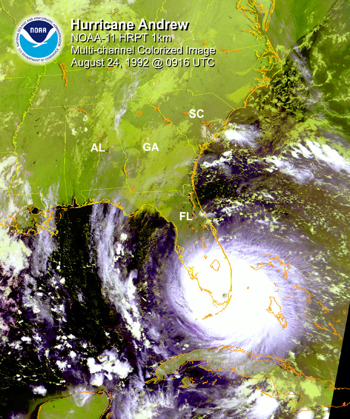
It’s a tight, small storm, and forecasters aren’t really sure exactly where it’s heading.They just know it’s moving East and is expected to approach South Florida before taking a jog to the North and hitting Broward County. In my South Dade Home, I’m confident it will veer to the North and miss us.
I’m wrong.
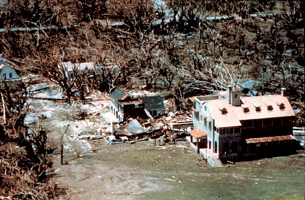
It picks up strength, and a small powerful Hurricane Andrew hits me full force, tearing up sections of my roof and terrorizing us as we huddle in the closet and hear the windows exploding from 160+ MPH winds.
That morning, we push away debris to open the closet door and see blue sky where our bathroom roof used to be.
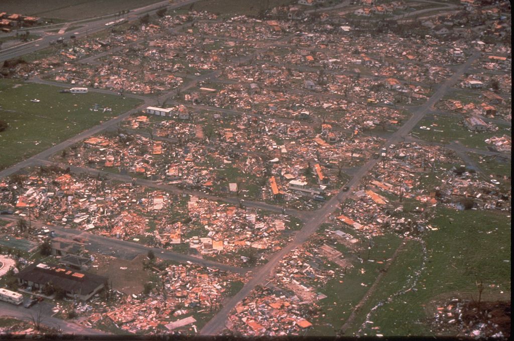
We survived one of the worst hurricanes in US history and our lives are changed forever. It takes almost a full year to get our home rebuilt and back in condition to move back in.
But every time it rains hard, every time the wind blows, it still brings back the terrible memories of that night when we thought we were going to die.
Those kind of memories never fade.
Changing ‘Hurricane Victims” into “Hurricane Survivors”
I’ve seen lots of homes rebuilt after Andrew, taking into account the lessons of missing nails, defective roofing, poor inspections and an oversight system bought and paid for developers and realtors seeking “affordable housing” to boost profits.
The “System” has supposedly been fixed.
But I have also seen lots of roofing and home improvement projects that look as if they still do not meet the current updated building codes spawned by Hurricane Andrew so many years ago.
As we approach the “Heart” of the 2016 Hurricane Season with several new storms developing the Atlantic, I wonder how ready everyone in South Florida may be for another possible Major Hurricane Hit.
Prepare NOW if you haven’t already.
Tropical Meteorology Experts at the National Center say we’re approaching the height of the season and NOW is the time to start paying more attention to your own Hurricane Survival Plans.
Dennis Feltgen of the National Hurricane Center passed this along. I think its good reading.
“Why does this peak period of activity begin so deep into summer? There certainly is no lack of disturbances throughout the entire six-month hurricane season. Tropical waves are coming off of the coast of Africa roughly every three days, and the very early and late parts of the year provide additional types of potential seedlings. What’s different, though, is the environment that these potential tropical cyclones tend to encounter. Both dynamics (wind factors) and thermodynamics (temperature and moisture) play a role.
Wind shear, which can tear disturbances apart before they strengthen, is strong in May, but gradually fades through June and July, reaching a minimum by mid to late August. This minimum in the shear combines with favorable thermodynamics – ocean temperatures in the deep tropics that increase with each day of summer sun, warmer air temperatures, and increasing atmospheric moisture.
When the dynamics and thermodynamics are in sync, as they often are from mid-August through early October, disturbances like African tropical waves can easily strengthen. The statistical peak day of the hurricane season – the day you are most likely to find a tropical cyclone somewhere in the Atlantic basin – is September 10th.”
Here’s some more good information for you and your families: https://www.ready.gov/hurricanes


